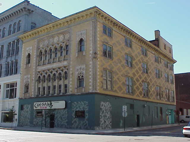
by Timothy Messer-Kruse
A monument is a curious way to record history. It is the oldest, most ancient form of history writing (what else is a pyramid or a statue but a memorial of some past?) and still remains a popular means of expressing historical ideas. Like the ancients, our society still etches its feats and stories in stone and metal.
A historical monument is a particular means of marking history. Unlike our other methods of remembering - through writing or speaking - a monument permits no dialogue. It stands, immovable, unalterable, silent and alone, speaking and never hearing. A speaker in a lecture hall can be interrupted, questioned, debated with. A book can be challenged by reviewers and argued with by other books that will stand shoulder to shoulder with them down through time on the shelves of our libraries. But a monument dominates its place. It has endurance - it shouts out during all the hours of the day and all the days of the year, year after year, to all who pass by "this is the way things have been - these are the things that are most important - and you should remember and honor them."
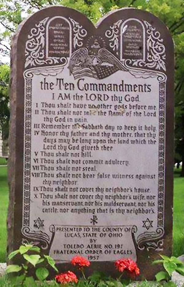
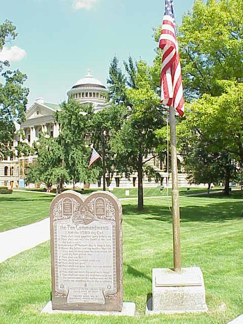
 ACLU's Bill of Rights Monument
 The Ten Commandments Monument
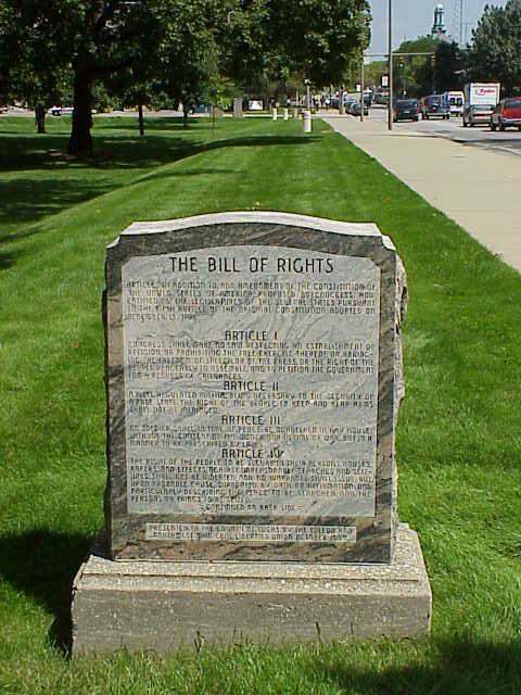
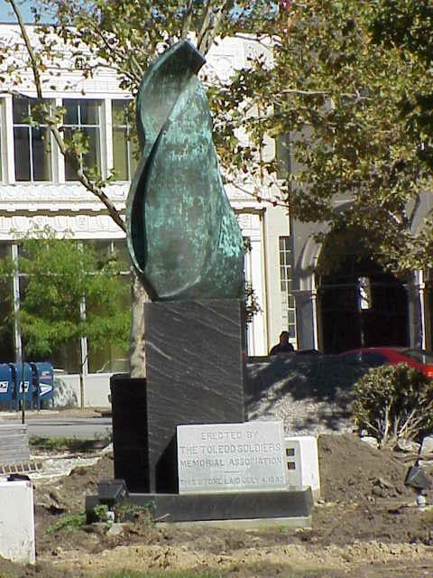
A monument's claim can only be challenged by illegal acts of defacement or by the placement of another monument nearby. Monuments are made of stone and bronze, not only because these materials will last through time, but also because they take great effort to alter and because they are expensive. To debate a monument with another monument is costly, though it is sometimes done (the A.C.L.U.'s Bill of Rights monument was placed a dozen yards from the ****'s Ten Commandments on the Lucas County Courthouse Square). Its more common for individuals to attempt to add a comment to one already standing, though these vandal scrawlings carry none of the credibility of a monument's precisely chiseled letters. Perhaps it is because historical monuments are the most one-sided means of remembering the past that they have been continuously used for over ten thousand years.
One of the purposes of this exhibit is to allow everyone the opportunity to argue with their monuments. Each monument or marker has been given its own page upon which is displayed its text and image. Alongside these words are blank spaces upon which anyone may inscribe their own responses, arguments, or memorials. Through this means the monopoly of history that monuments represent is at least partially overturned.
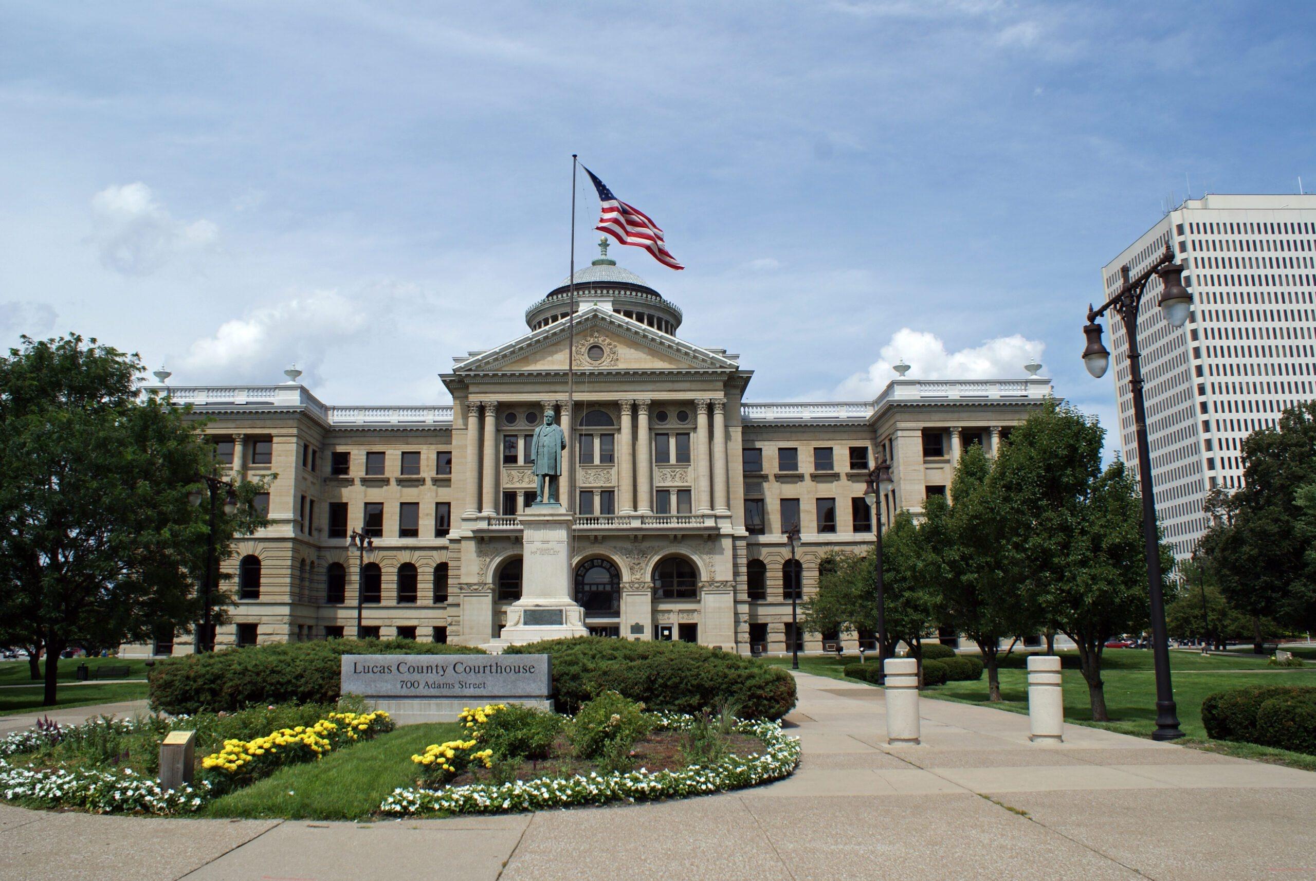
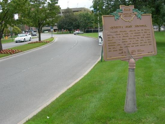
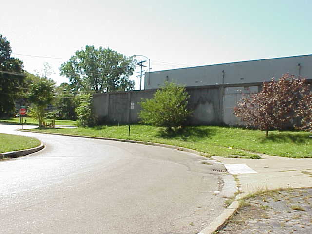
The power of a monument, unlike other types of history remembering, is drawn from its surroundings, its place. Some monuments are placed in an important, and highly trafficked public place as a way of emphasizing the importance of a person or event. The manicured flowerbeds and classical architecture of the Lucas County Courthouse not only serves as a backdrop to the William McKinley Monument, they dramatically add to its air of dignity and importance. In contrast, the historical marker that notes the location of the city's first hospital sits on a traffic island in the middle of a hospital's busy driveway. The only way to actually read the sign is to park illegally, partially blocking traffic, and walking across a swath of grass. (Within five minutes of my making this trek to read the sign, hospital security was deployed to tell me that this was private property and that I needed written permission to be where I was.) Such an inaccessible location says to the world, 'something once happened here, but its not of much importance.'
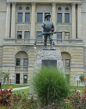
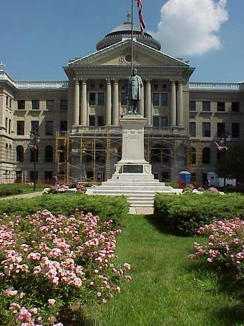
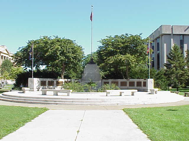
Where things are placed can have political dimensions as well. For example, it is interesting that the Spanish-American War Veterans Monument, also located on the courthouse square, is situated on the opposite side of the building so that it is impossible to view both monuments simultaneously. Though the deaths of the soldiers remembered on one side of the building was the result of orders given by the man immortalized on the other, this relationship is guiltily hidden by the visual separation of the two.
 The Spanish Civil War Memorial
 The William McKinley Memorial
It is for this reason that merely photographing the monuments themselves cannot reveal their entire meaning. Rather, the monuments and their surroundings must be shown together, a task that traditional photography has only a limited ability to do but that computers now make possible in new ways. VR panorama photography allows for the capturing of a complete three hundred and sixty degree view of a landscape. Viewed on a computer these panoramas are seamless and controllable by the viewer and reveals more than what the monument tells you to look at.[1]
Finally, this exhibit is also an inventory of what generations of people in Toledo and Lucas County have considered worth remembering. The list of what has been marked and monumented reveals more about what each generation has valued than what of historical importance has actually occurred in the area. When people of a certain age construct a monument to the past, they are in fact not immortalizing the past, but preserving a piece of themselves. Of the monuments found below, about a third commemorate business or commerce; as many recognize the slain in our nation's wars; some chronicle the history of government or its public servants; the remainder primarily mark the founding of charitable and cultural institutions. Only one memorial, the Richard Gosser Memorial, notes an achievement of workers, only two celebrate neighborhoods, and only one recognizes the diversity of Toledo's population. Judging by our memorials, we are a community concerned mostly with business and respectful of the sacrifices of our defenders.
Timothy Messer-Kruse, University of Toledo, September 11, 2000
Exhibit Gallery


Acknowledgments
Thanks to Cheryl Trumbull for retyping many of the marker inscriptions. Thanks to Carl N. White for sending lists of historic buildings from the LC-MVHS Landmarks Committee and to Bonnie Such from the Local History Office of the Ohio Historical Society (Columbus) for finding lists of OHS historical markers in Lucas County. Also thanks to Emmett and Connor Messer-Kruse for being good company while being dragged around the county taking pictures of "those old things."
Use the index on the right for information on individual historical markers and monuments in and around Toledo.
Image credits: Remarkable Ohio, Lucas County
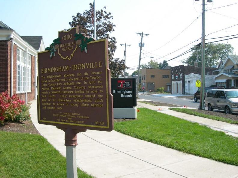
Birmingham-Ironville (16-48)
")
Location: SE corner of Paine Avenue and Genesee Street [Google Street View]
Text, Side A: The Birmingham and Ironville neighborhoods were so named because of their early iron industries located along Front Street and the Maumee River. This became Toledo's first area of heavy industrial development with iron manufacturing, coal shipping, oil refining, shipbuilding, and flour milling operations. In 1864 the Manhattan Iron Company built a charcoal blast furnace near the river's mouth, securing fuel from nearby forests.
Text, Side B: The neighborhood adjoining the site became known as Ironville and is now part of the Toledo-Lucas County Port Authority site. In 1890 the National Malleable Casting Company sponsored nearly a hundred Hungarian families to move to East Toledo. These immigrants formed the core of the Birmingham neighborhood which continues to retain its strong ethnic heritage and cultural pride.
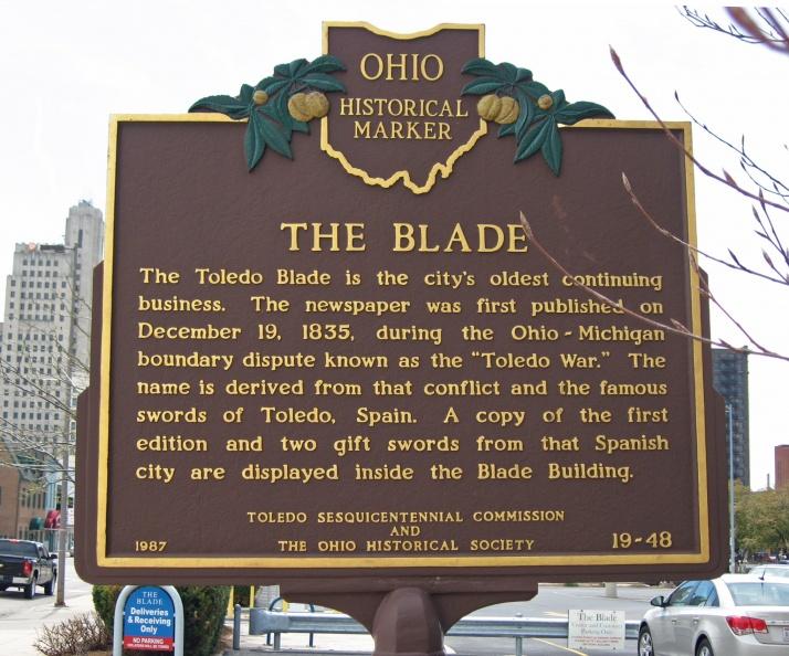
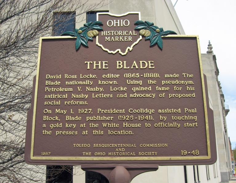
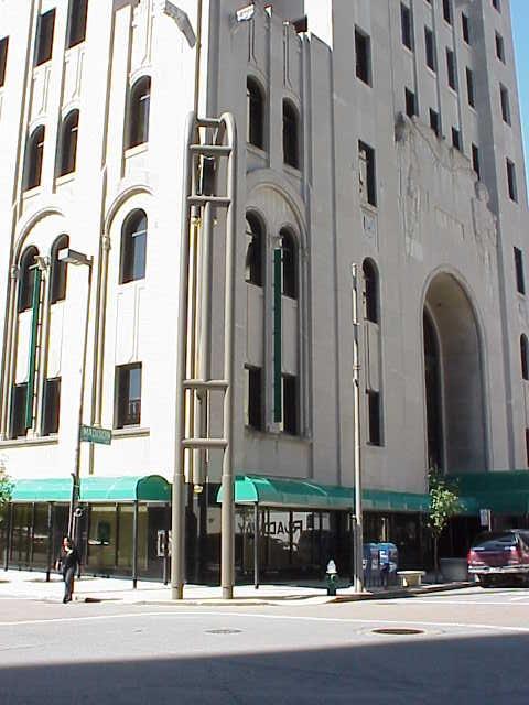
The Blade (19-48)
")
Location: 541 N. Superior Street, Toledo, OH, 43660 [Google Street View]
Text: The Toledo Blade is the city’s oldest continuing business. The newspaper was first published on December 19, 1835, during the Ohio-Michigan boundary dispute known as the "Toledo War." The name is derived from that conflict and the famous swords of Toledo, Spain. A copy of the first edition and two gift swords from that Spanish city are displayed inside the Blade Building.
")
Text:David Ross Locke, editor (1865-1888), made The Blade nationally known. Using the pseudonym Petroleum V. Nasby, Locke gained fame for his satirical Nasby Letters and advocacy of social reforms. On May 1, 1927, President Coolidge assisted Paul Block, Blade publisher (1926-1941), by touching a gold key at the White House to officially start the presses at this location.
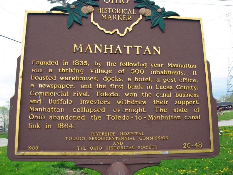
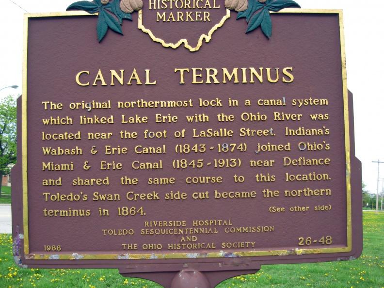
Canal Terminus (26-48)
")
Location: Northeast corner of N Summit Street (3900 N Summit Street) and Erie Street. NOTE: The whereabouts of the actual marker is unknown [Google Street View]
Text, Side A: The original northernmost lock in a canal system which linked Lake Erie with the Ohio River was located near the foot of LaSalle Street. Indiana's Wabash & Erie Canal (1843-1874) joined Ohio's Miami & Erie Canal (1845-1913) near Defiance and shared the same course to this location. Toledo's Swan Creek side cut became the northern terminus in 1864.
Text, Side B: Founded in 1835, by the following year Manhattan was a thriving village of 500 inhabitants. It boasted warehouses, docks, a hotel, a post office, a newspaper, and the first bank in Lucas County. Commercial rival, Toledo, won the canal business and Buffalo investors withdrew their support. Manhattan collapsed overnight. The state of Ohio abandoned the Toledo-to-Manhattan canal link in 1864.
East Toledo (15-48)


Location: Originally located in the park between Main and Platt streets on the vacated 1st Street, Toledo, the marker has been permanently removed. [Google Street View]
Original Text, Side A: East Toledo, early home of Ottawa Indians and originally part of Oregon Township, was annexed to the city in 1853. Peter Navarre, fur trader and War of 1812 scout, was a well-known pioneer resident. A post office named Utah was established in 1851 and located on Front Street near Oak Street, then the commercial center of the East Side.
Original Text, Side B: Toledo’s first public bridge over the Maumee River was a privately financed toll operation which opened in 1865 and joined Cherry and Main streets. A gala celebration in 1872 marked the city’s purchase of the bridge and lifting of its tolls. Free access to this vital river crossing stimulated further development and rapid growth of East Toledo.
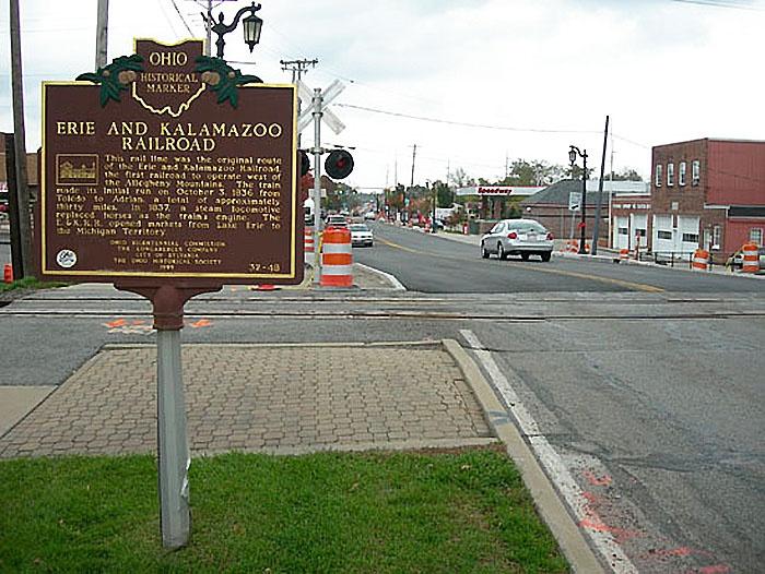
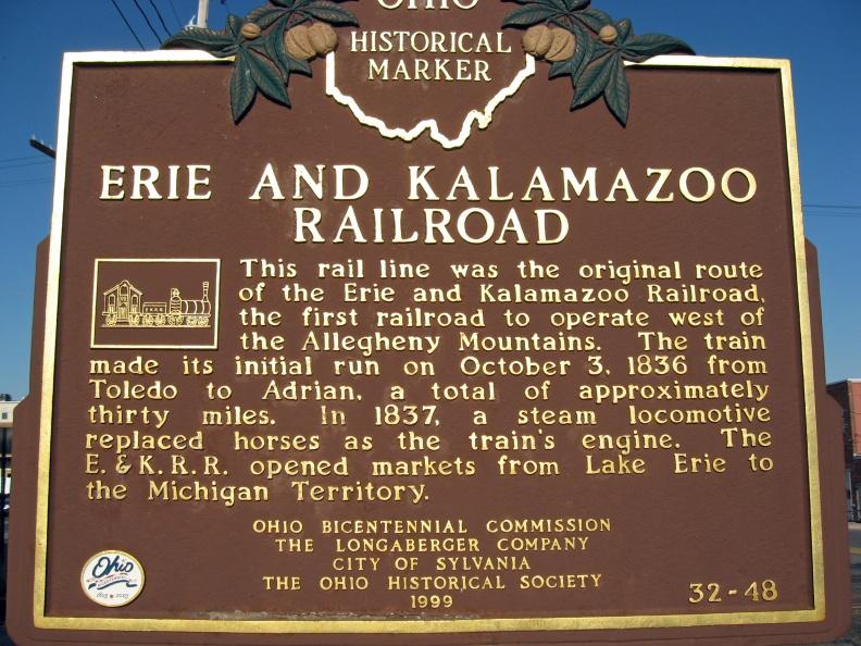
Erie and Kalamazoo Railroad (32-48)
")
, close-up view")
Location: Northwest corner of Monroe Street and railroad tracks, just east of 670 Monroe Street, Sylvania, Ohio [Google Street View]
Text: This rail line was the original route of the Erie and Kalamazoo Railroad, the first railroad to operate west of the Allegheny Mountains. The train made its initial run on October 3, 1836 from Toledo to Adrian, a total of approximately thirty miles. In 1837, a steam locomotive replaced horses as the train's engine. The E. & K. R.R. opened markets from Lake Erie to the Michigan Territory.
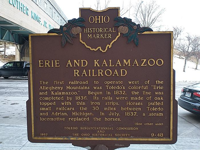
Erie and Kalamazoo Railroad (9-48)
")
Location: Marker is in Southside, Ohio, in Lucas County. Marker is on Emerald Street at the entrance of the Central-Union Plaza on Emerald Street. [Google Street View]
Text, Side A: Erie and Kalamazoo Railroad. The first railroad to operate west of the Allegheny Mountains was Toledo's colorful "Erie and Kalamazoo." Begun in 1832, the line was completed by 1836. Its rails were made of oak topped with thin iron strips. Horses pulled small railcars the 30 miles between Toledo and Adrian, Michigan. In July, 1837, a steam locomotive replaced the horses.
")
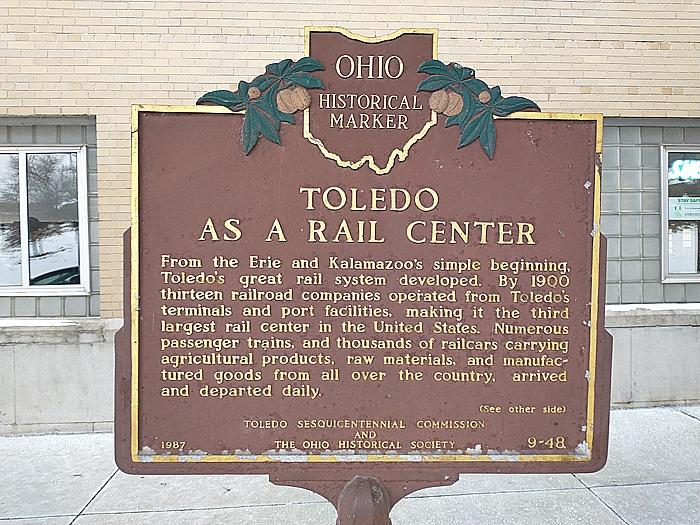
Text, Side B: Toledo as a Rail Center. From the Erie and Kalamazoo's simple beginning, Toledo's great rail system developed. By 1900 thirteen railroad companies operated from Toledo's terminal and port facilities, making it the third largest rail center in the United States. Numerous passenger trains, and thousands of railcars carrying agricultural products, raw materials, and manufactured goods from all over the country, arrived and departed daily.
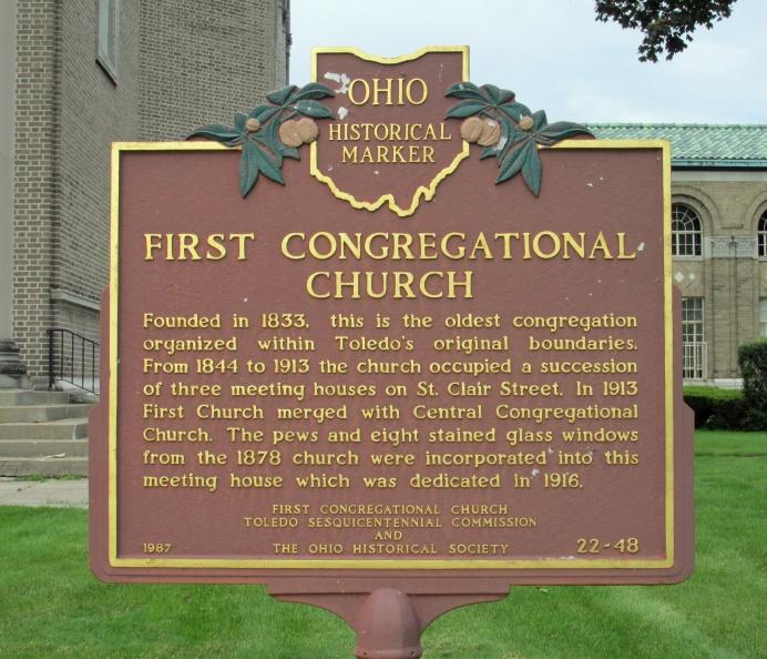
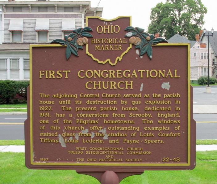
First Congregational Church (22-48)
")
Location: 2315 Collingwood Boulevard, Toledo, Ohio [Google Street View]
Text: Founded in 1833, this is the oldest congregation organized within Toledo's original boundaries. From 1844 to 1913 the church occupied a succession of three meeting houses on St. Clair Street. In 1913 First Church merged with Central Congregational Church. The pews and eight stained glass windows from the 1878 church were incorporated into this meeting house which was dedicated in 1916.
")
Text: The adjoining Central Church served as the parish house until its destruction by gas explosion in 1927. The present parish house, dedicated in 1931, has a cornerstone from Scrooby, England, one of the Pilgrims' hometowns. The windows of this church offer outstanding examples of stained glass from the studios of Louis Comfort Tiffany, Louis Lederle, and Payne-Speers.
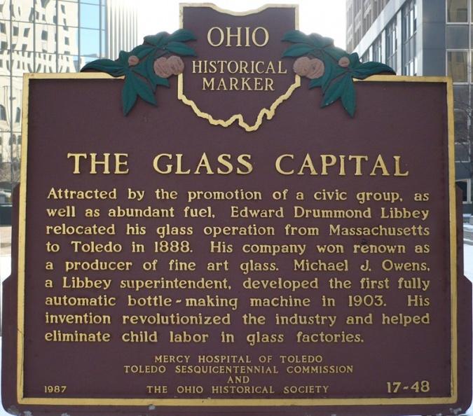
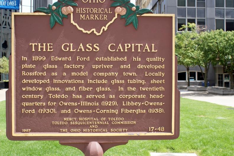
The Glass Capital (17-48)
")
Location: Southeast corner of 200 N St. Clair St and Madison Ave, north of the fountain in Levis Square Park. [Google Street View]
Text: Attracted by the promotion of a civic group, as well as abundant fuel, Edward Drummond Libbey relocated his glass operation from Massachusetts to Toledo in 1888. His company was renown as a producer of fine art glass. Michael J. Owens, a Libbey Superintendent, developed the first fully automatic bottle-making machine in 1903. His invention revolutionized the industry and helped eliminate child labor in glass factories.
")
Text: In 1899 Edward Ford established his quality plate glass factory upriver and developed Rossford as a model company town. Locally developed innovations include glass tubing, sheet window glass, and fiber glass. In the twentieth century Toledo has served as corporate headquarters for Owens-Illinois (1929), Libbey-Owens-Ford (1930), and Owens-Corning Fiberglass (1938).
Note: the historical marker has been moved (again) and is farther away from this Google Street View point.
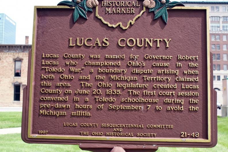
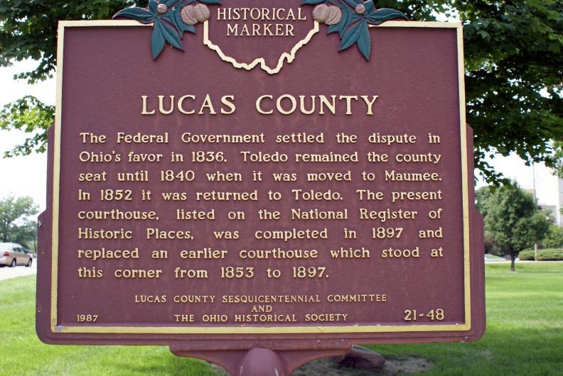
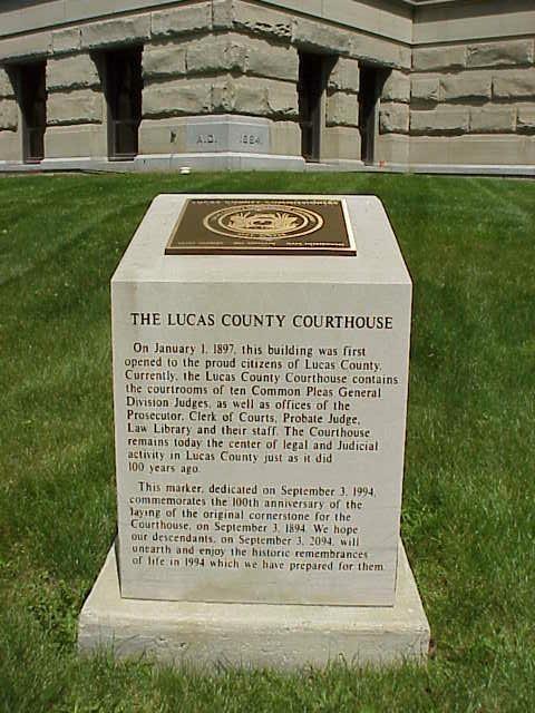
Lucas County and Courthouse (21-48)
")
Location: The Remarkable Ohio websties reports that the current location of the marker is not known. Last known location was the corner of Adams and N. Erie Streets. [Google Street View]
Text Side A: Side A: Lucas County was named for Governor Robert Lucas who championed Ohio’s cause in the “Toledo War,” a boundary dispute arising when both Ohio and the Michigan Territory claimed this area. The Ohio legislature created Lucas County on June 20, 1835. The first court session convened in a Toledo schoolhouse during the pre-dawn hours of September 7 to avoid the Michigan militia.
")
Text, Side B: The Federal Government settled the dispute in Ohio’s favor in 1836. Toledo remained the county seat until 1840 when it was moved to Maumee. In 1852 it was returned to Toledo. The present courthouse, listed on the National Register of Historic Places, was completed in 1897 and replaced an earlier courthouse which stood at this corner from 1853 to 1897.
*Note: The street view is an approximate location based on background identification
")

The present courthouse, listed on the National Register of Historic Places, was completed in 1897 and replaced an earlier courthouse which stood at this corner from 1853 to 1897.
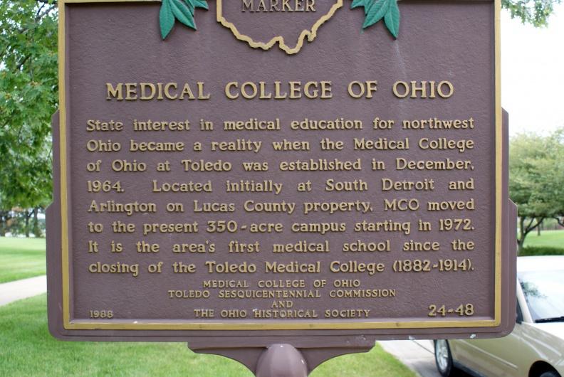
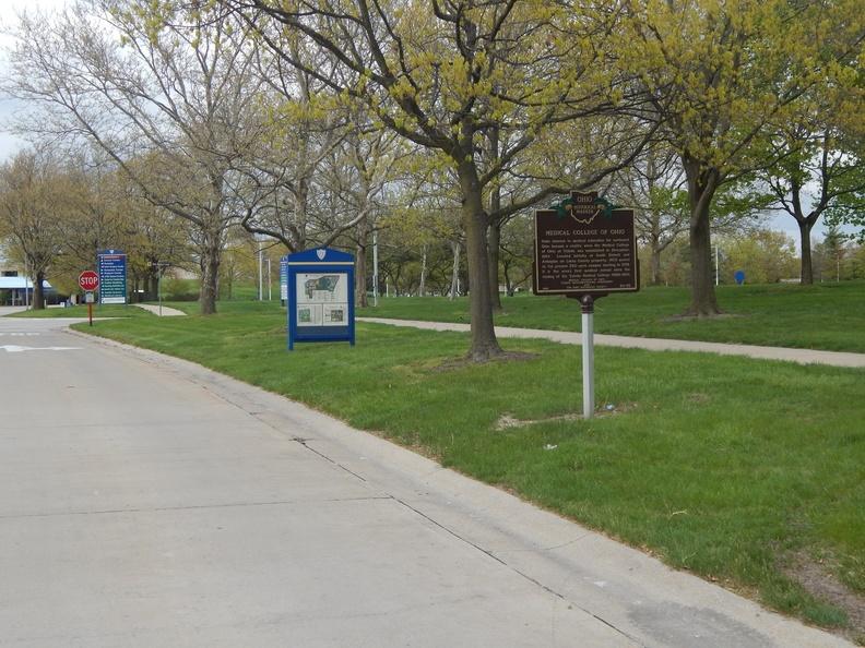
Medical College of Ohio (24-48)
")
Location: East side MUOT Blvd, North of Glendale Avenue. [Google Street View]
Text: State interest in medical education for northwest Ohio became a reality when the Medical College of Ohio at Toledo was established in December, 1964. Located initially at South Detroit and Arlington on Lucas County property, MCO moved to the present 350-acre campus starting in 1972. It is the area's first medical school since the closing of the Toledo Medical College (1882-1914).
")
View of the sign from MUOT Blvd
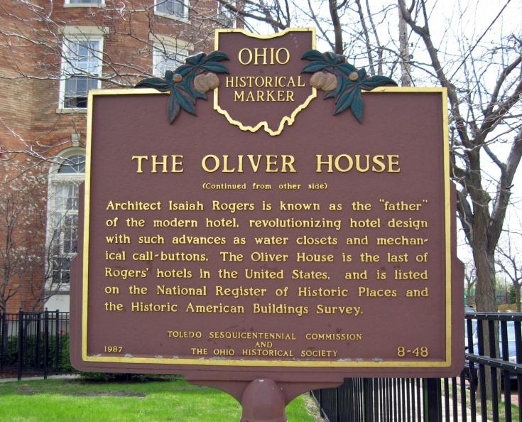
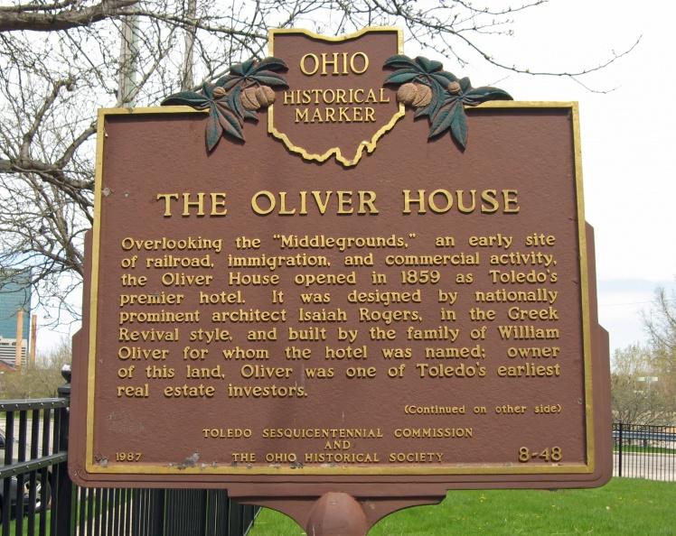
The Oliver House (8-48)
")
Location: In front of the Oliver House at Broadway Street and Ottawa Street. [Google Street View]
Text, Side A: Overlooking the "Middlegrounds," an early site of railroad, immigration, and commercial activity, the Oliver House opened in 1859 as Toledo's premier hotel. It was designed by nationally prominent architect Isaiah Rogers, in the Greek Revival style, and built by the family of William Oliver for whom the hotel was named; owner of this land, Oliver was one of Toledo's earliest real estate investors
")
Text, Side B: (Continued from other side) Architect Isaiah Rogers is known as the “father” of the modern hotel, revolutionizing hotel design with such advances as water closets and mechanical call-buttons. The Oliver House is the last of Rogers’ hotels in the United States, and is listed on the National Register of Historic Places and the Historic American Buildings Survey.
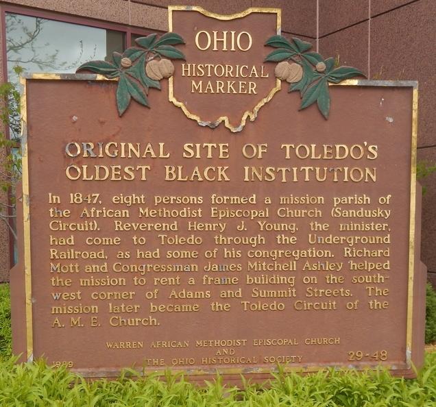
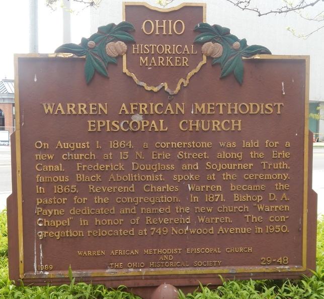
Original Site of Toledo’s Oldest Black Institution (29-48)
")
Location: 333 N Summit Street, Toledo, Ohio. There does not appear top be a marker at this location. [Google Street View]
Text, Side A: Original Site of Toledo's Oldest Black Institution. In 1847, eight persons formed a mission parish of the African Methodist Episcopal Church (Sandusky Circuit). Reverend Henry J. Young, the minister, had come to Toledo through the Underground Railroad, as had some of his congregation. Richard Mott and Congressman James Mitchell Ashley helped the mission to rent a frame building on the southwest corner of Adams and Summit streets. The mission later became the Toledo Circuit of the A.M.E. Church.
")
Text, Side B: Warren African Methodist Episcopal Church. On August 1, 1864, a cornerstone was laid for a new church at 15 N. Erie Street, along the Erie Canal. Frederick Douglass and Sojourner Truth, famous Black Abolitionists, spoke at the ceremony. In 1865, Reverend Charles Warren became the pastor for the congregation. In 1871, Bishop D. A. Payne dedicated and named the new church “Warren Chapel” in honor of Reverend Warren. The congregation relocated at 749 Norwood Avenue in 1950.
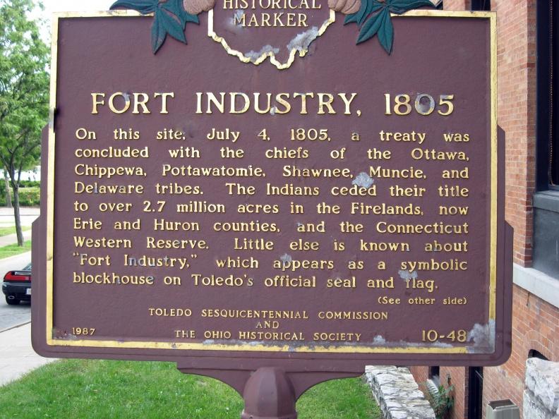
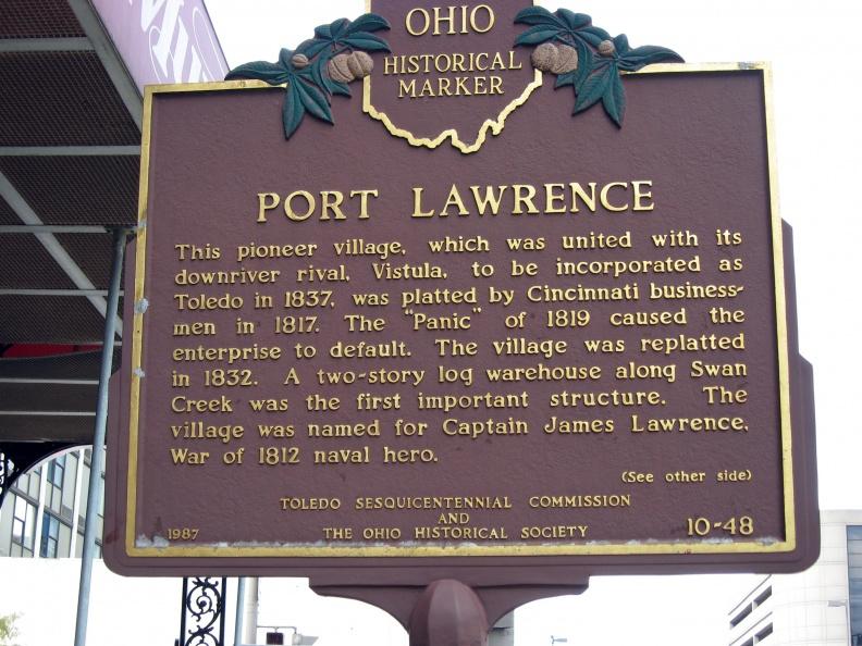
Port Lawrence and Fort Industry, 1805 (10-48)
")
Location: Southeast corner of N Summit Street and Jefferson Avenue,Toledo, Ohio. [Google Street View]
Text, Side A: This pioneer village, which was united with its downriver rival, Vistula, to be incorporated as Toledo in 1837, was platted by Cincinnati businessmen in 1817. The "Panic" of 1819 caused the enterprise to default. The village was re-platted in 1832. A two-story log warehouse along Swan Creek was the first important structure. The village was named for Captain James Lawrence, War of 1812 naval hero.
")
Text, Side B: Fort Industry, 1805. On this site, July 4, 1805, a treaty was concluded with the chiefs of the Ottawa, Chippewa, Pottawatomie, Shawnee, Muncie, and Delaware tribes. The Indians ceded their title to over 2.7 million acres in the Firelands, now Erie and Huron counties, and the Connecticut Western Reserve. Little else is known about "Fort Industry," which appears as a symbolic blockhouse on Toledo's official seal and flag.
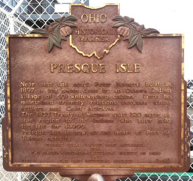
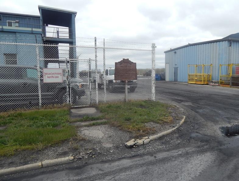
Presque Isle (1-48)
")
Location: Inside the secure Midwest Terminal, 3518 St. Lawrence Drive, Toledo, Ohio. Not accessibile to the general public. [Google Map Location]*
Text: Near this site scout Peter Navarre built in 1807 a log cabin close by an Ottawa Indian Village of 60 whitewashed cabins. Here he maintained friendly relations between white settlers and Chief Autokee. The 1833 Treaty of Maumee gave 320 acres of this region to the Indians who later sold the isle for $1,000. Presque Isle is now at the heart of Port of Toledo activity.
")
A view of the historical marker at the site, which is not accessibile to the general public.
*Note: Google Street View is not available for this location.
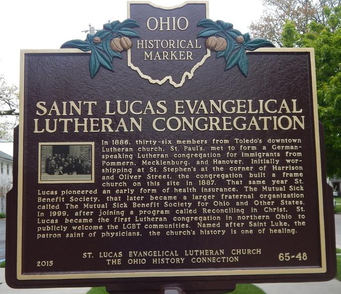
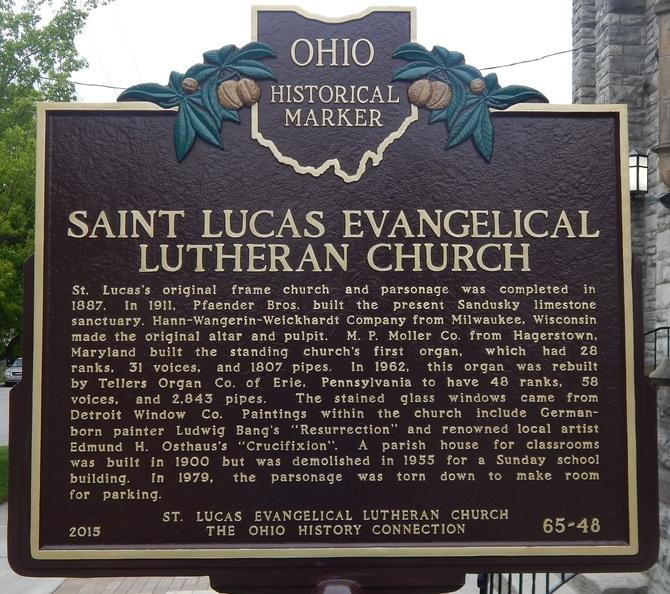
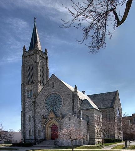
St. Lucas Evangelical Lutheran Congregation and Church (65-48)
")
Location: 745 Walbridge Ave, Toledo, OH. [Google Street View]
Text, Side A: Saint Lucas Evangelical Lutheran Congregation. In 1886, thirty-six members from Toledo's downtown Lutheran church, St. Paul's, met to form a German-speaking Lutheran congregation for immigrants from Pommern, Mecklenburg and Hanover. Initially worshipping at St. Stephen's at the corner of Harrison and Oliver Street, the congregation built a frame church on this site in 1887. That same year St. Lucas pioneered an early form of health insurance, The Mutual Sick Benefit Society, that later became a larger fraternal organization called The Mutual Sick Benefit Society for Ohio and Other States. In 1999, after joining a program called Reconciling in Christ, St. Lucas became the first Lutheran congregation in northern Ohio to publicaly welcome the LGBT communities. Named after Saint Luke, the patron saint of physicians, the church's history is one of healing.
")
Text, Side B: Saint Lucas Evangelical Lutheran Church. St. Lucas's orginal frame church and parsonage was completed in 1887. In 1911, Pfaender Bros. built the present Sandusky limestone sanctuary. Hann-Wangerin-Weickhart Company from Milwaukee, Wisconsin made the original alter and pulpit. M.P. Moller Co. from Hagarstown, Maryland built the standing church's first organ, which had 28 ranks, 31 voices and 1,807 pipes. In 1962, this organ was rebuilt by Tellers Organ Co. of Erie, Pennsylvania to have 48 ranks, 58 voices and 2,843 pipes. The stained glass windows came from Detroit Window Co. Paintings within the church include German-born painter Ludwig Bang's "Resurrection" and renowned local artist Edmund H. Osthaus's "Crucifixion." A parish house for classrooms was built in 1900 but was demolished in 1955 for a Sunday school building. In 1979, the parsonage was torn down to make room for parking.
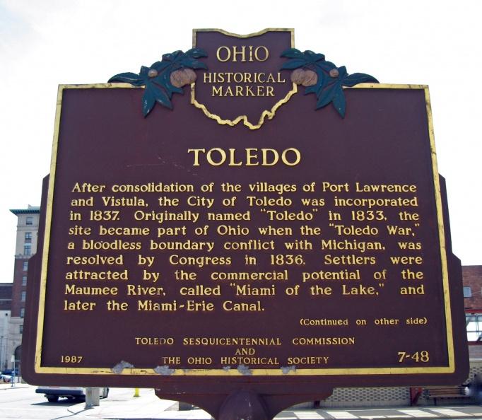
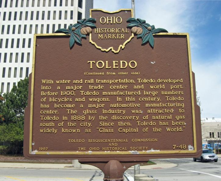
Toledo (7-48)
")
Location: West side of N Huron Street and Jackson Street, Toledo, Ohio. [Google Street View]
Text, Side A: After consolidation of the villages of Fort Lawrence and Vistula, the City of Toledo was incorporated in 1837. Originally named "Toledo" in 1833, the site became part of Ohio when the "Toledo War," a bloodless boundary conflict with Michigan, was resolved by Congress in 1836. Settlers were attracted by the commercial potential of the Maumee River, called "Miami of the Lake," and later the Miami-Erie Canal.
")
Text, Side B: With water and rail transportation, Toledo developed into a major trade center and world port. Before 1900, Toledo manufactured large numbers of bicycles and wagons. In this century, Toledo has become a major automotive manufacturing center. The glass industry was attracted to Toledo in 1888 by the discovery of natural gas south of the city. Since then, Toledo has been widely known as "Glass Capital of the World."
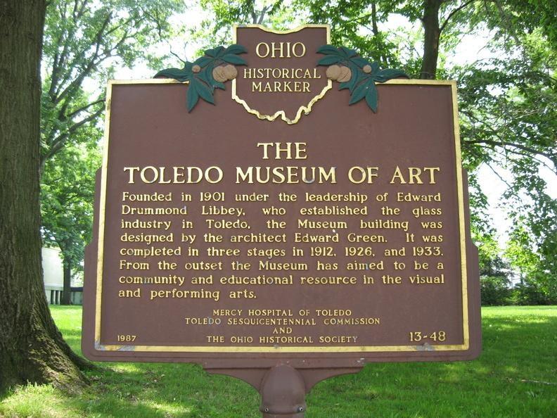
Toledo Museum of Art (13-48)
")
Location: On museum grounds along Monroe Street, Toledo. [Google Street View]
Text: Founded in 1901 under the leadership of Edward Drummond Libbey, who established the glass industry in Toledo, the Museum building was designed by the architect Edward Green. It was completed in three stages in 1912, 1926, and 1933. From the outset the Museum has aimed to be a community and educational resource in the visual and performing arts.
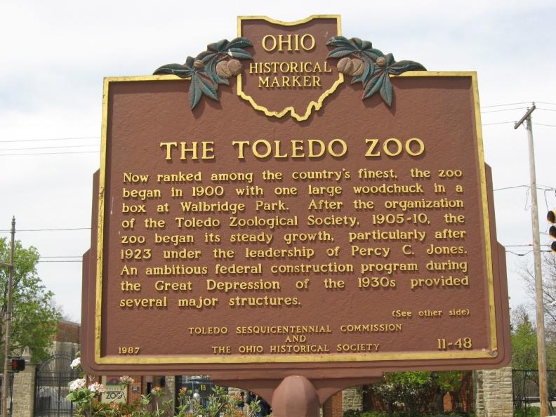
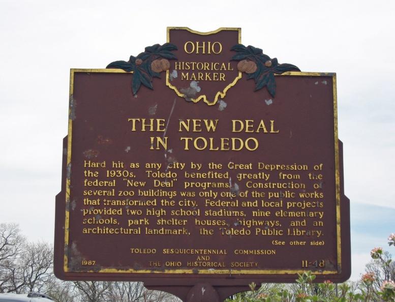
The Toledo Zoo; The New Deal in Toledo (11-48)
")
Location: Across from 2700 Broadway Street, Toledo, Ohio. [Google Street View]
Text: The Toledo Zoo. Now ranked among the country's finest, the zoo began in 1900 with one large woodchuck in a box at Walbridge Park. After the organization of the Toledo Zoological Society, 1905-10, the zoo began its steady growth, particularly after 1923 under the leadership of Percy C. Jones. An ambitious federal construction program during the Great Depression of the 1930s provided several major structures.
")
Text: The New Deal in Toledo. Hard hit as any city by the Great Depression of the 1930s, Toledo benefited greatly from the federal "New Deal" programs. Construction of several zoo buildings was only one of the public works that transformed the city. Federal and local projects provided two high school stadiums, nine elementary schools, park shelter houses, highways, and an architectural landmark, the Toledo Public Library.
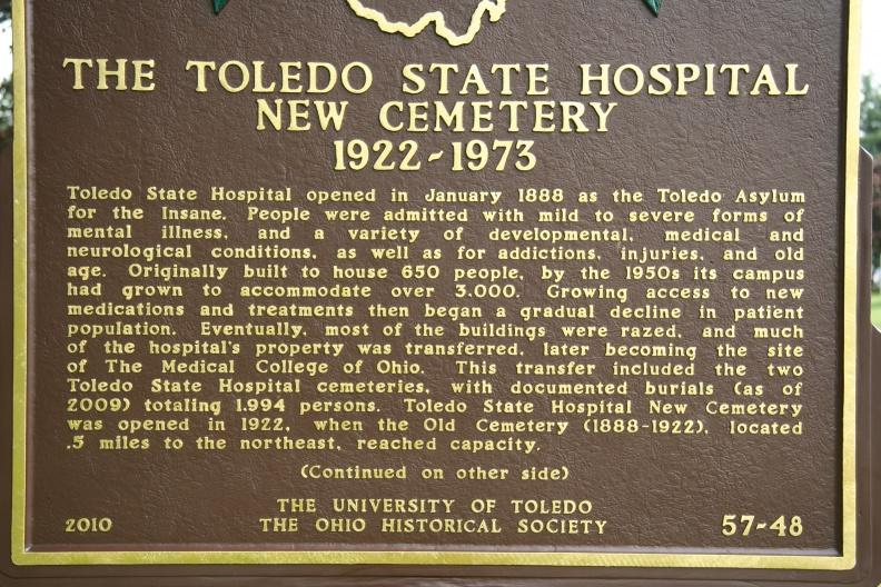
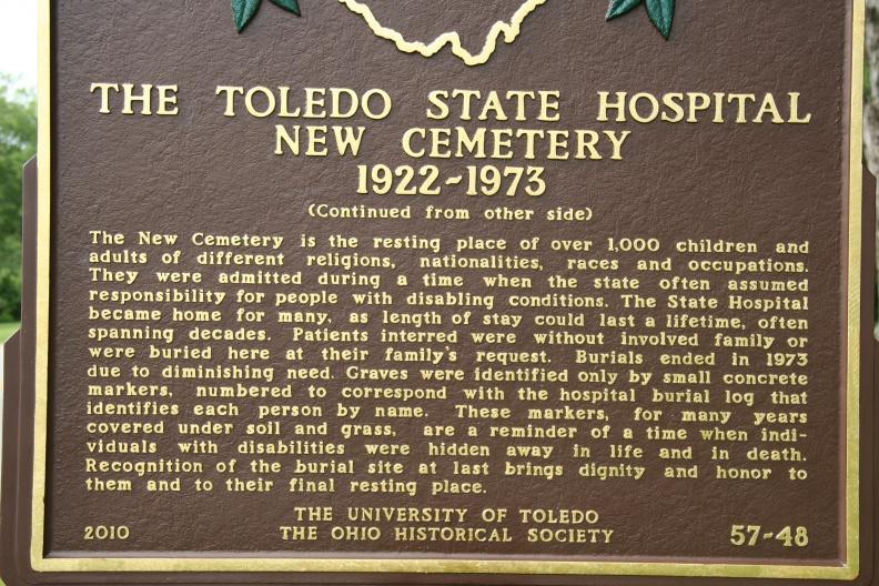
The Toledo State Hospital New Cemetery, 1922-1937 (57-48)
")
Location: Arlington Avenue, Toledo Ohio, east of Bowsher High School. [Google Street View]
Text, Side A: Toledo State Hospital opened in January 1888 as the Toledo Asylum for the Insane. People were admitted with mild to severe forms of mental illness, and a variety of developmental, medical and neurological conditions, as well as for addictions, injuries, and old age. Originally built to house 650 people, by the 1950s its campus had grown to accommodate over 3,000. Growing access to new medications and treatments then began a gradual decline in patient population. Eventually, most of the buildings were razed, and much of the hospital's property was transferred, later becoming the site of The Medical College of Ohio. This transfer included the two Toledo State Hospital cemeteries, with documented burials (as of 2009) totaling 1,994 persons. Toledo State Hospital New Cemetery was opened in 1922, when the Old Cemetery (1888-1922), located .5 miles to the northeast, reached capacity.
")
Text: The New Cemetery is the resting place of over 1,000 children and adults of different religions, nationalities, races and occupations. They were admitted during a time when the state often assumed responsibility for people with disabling conditions. The State Hospital became home for many, as length of stay could last a lifetime, often spanning decades. Patients interred were without involved family or were buried here at their family's request. Burials ended in 1973 due to diminishing need. Graves were identified only by small concrete markers, numbered to correspond with the hospital burial log that identifies each person by name. These markers, for many years covered under soil and grass, are a reminder of a time when individuals with disabilities were hidden away in life and in death. Recognition of the burial site at last brings dignity and honor to them and to their final resting place.
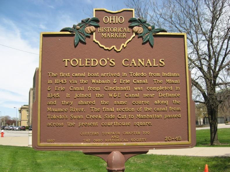
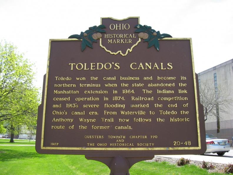
Toledo’s Canals (20-48)
")
Location: Courthouse square, SE corner of N Michigan Street and Jackson Street. [Google Street View]
Text, Side A: The first canal boat arrived in Toledo from Indiana in 1843 via the Wabash & Erie Canal. The Miami & Erie Canal from Cincinnati was completed in 1845. It joined the W & E Canal near Defiance and they shared the same course along the Maumee River. The final section of the canal from Toledo’s Swan Creek Side Cut to Manhattan and passed across the present courthouse square.
")
Text, Side B: Toledo won the canal business and became its northern terminus when the state abandoned the Manhattan extension in 1864. The Indiana link ceased operation in 1874. Railroad competition and 1913's severe flooding marked the end of Ohio's canal era. From Waterville to Toledo the Anthony Wayne Trail now follows the historic route of the former canals.
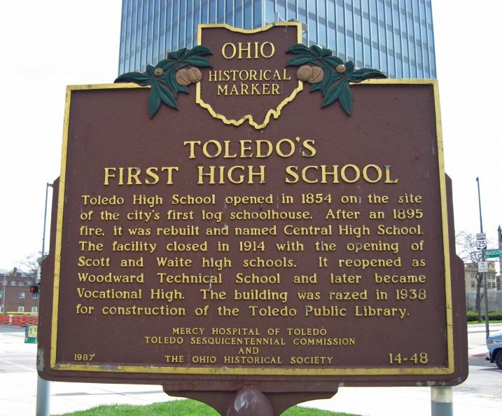
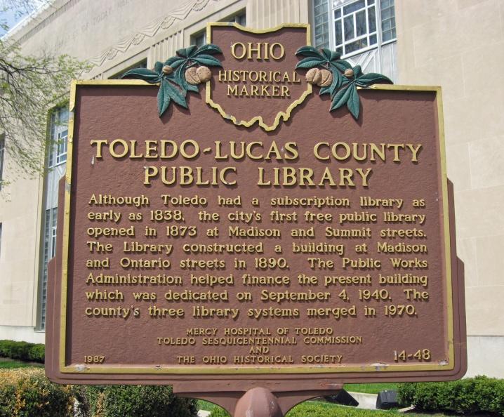
Toledo’s First High School; Toledo Lucas County Public Library (14-48)
")
Location: Northwest corner of N Michigan Street and Madison Avenue. [Google Street View]
Text, Side A: Toledo High School opened in 1854 on the site of the city's first log schoolhouse. After an 1895 fire, it was rebuilt and named Central High School. The facility closed in 1914 with the opening of Scott and Waite high schools. It reopened as Woodward Technical School and later became Vocational High. The building was razed in 1938 for construction of the Toledo Public Library.
")
Text, Side B: Although Toledo had a subscription library as early as 1838, the city's first free public library opened in 1873 at Madison and Summit streets. The library constructed a building at Madison and Ontario streets in 1890. The Public Works Administration helped finance the present building which was dedicated on September 4, 1940. The county's three library systems merged in 1970.
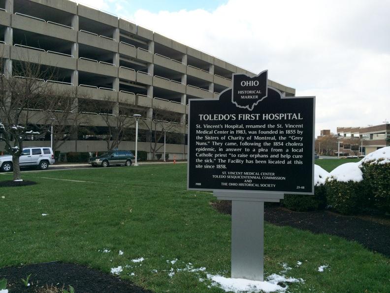
Toledo’s First Hospital (25-48)
")
Location: By St. Vincent Medical Center near the Cherry Street entrance to the parking area opposite Frederick Street, Toledo
Text, Side A: St. Vincent's Hospital, renamed the St. Vincent Medical Center in 1983, was founded in 1855 by the Sisters of Charity of Montreal, the "Grey Nuns." They came, following the 1854 cholera epidemic, in answer to a plea from a local Catholic priest "to raise orphans and help cure the sick." The facility has been located at this site since 1858.
")
Text, Side B: St. Vincent’s has pioneered many of Toledo’s medical "firsts", among which are: 1869: First school of nursing which was Ohio’s first Catholic school of nursing. 1915: First hospital to install x-ray equipment. 1955: First hospital to have a department of nuclear medicine. 1967: First Burn Unit in NW Ohio. 1975: First to have hospital-based alcoholism treatment center. 1979: First area Life Flight service.
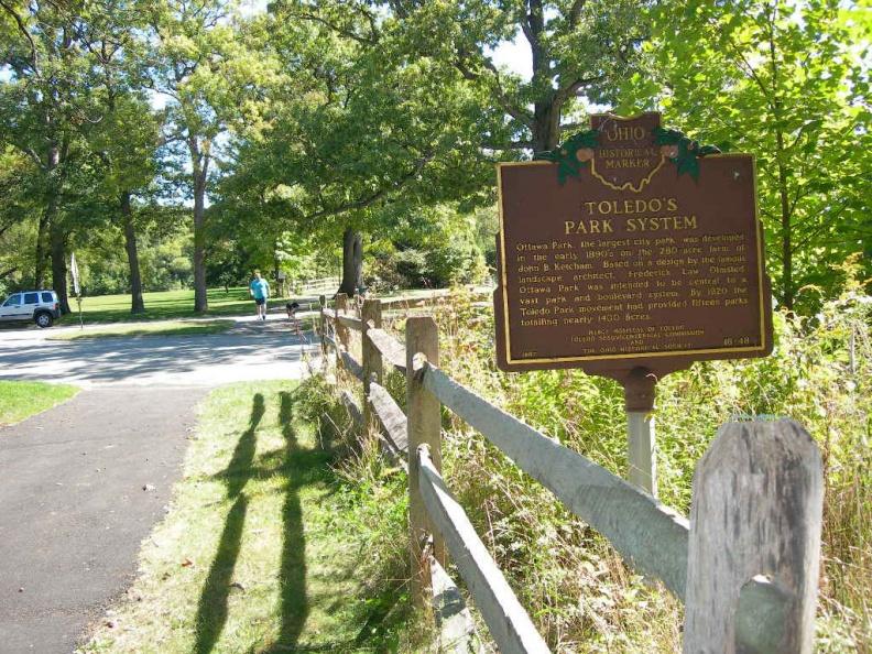
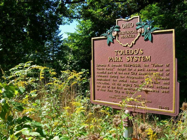
Toledo's Park System (18-48)
")
Location: Visible from Midwood Lane in Ottawa Park
Text, Side A: Ottawa Park, the largest city park, was developed in the early 1890s on the 280-acre farm of John B. Ketcham. Based on a design by the famous landscape architect, Frederick Law Olmsted, Ottawa Park was intended to be central to a vast park and boulevard system. By 1920 the Toledo Park movement had provided fifteen parks totaling nearly 1400 acres.
")
Text, Side B: Sylvanus P. Jermain (1859-1935), the "Father of Toledo Parks," fought for a park system as an essential part of the new City Beautiful ideal of reformers during the Progressive Era. Jermain emphasized the social value of exercise and recreation. At his urging Ottawa Park became the site of the first municipal golf course west of New York City in 1899.
Use the interactive map to explore Metroparks Toledo (Present) [Map link: Metroparks]

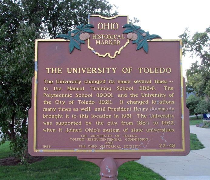
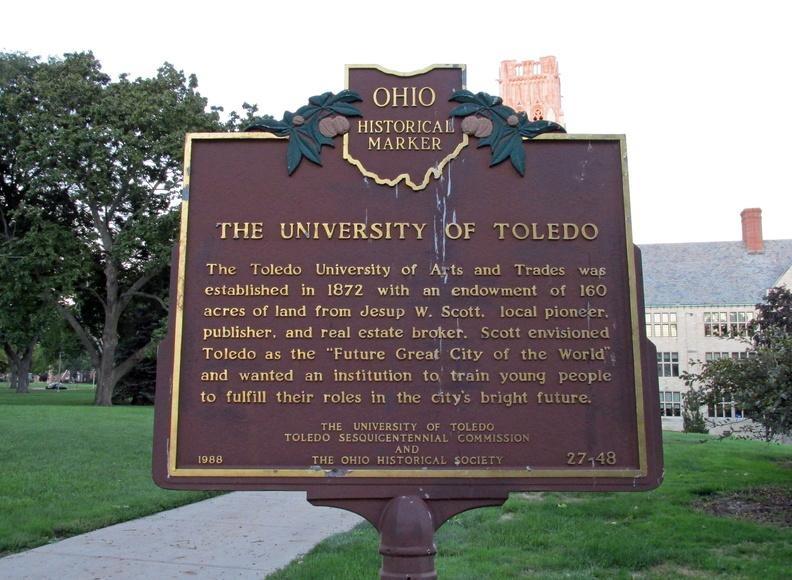
The University of Toledo, Main Campus (27-48)
")
Location: East of Campus Road, S of Bancroft Street, on walkway east of Libbey Hall. [No Google Street view for this marker, approximate only]
Text, Dide A: The Toledo University of Arts and Trades was established in 1872 with an endowment of 160 acres of land from Jesup W. Scott, local pioneer, publisher, and real estate broker. Scott envisioned Toledo as the "Future Great City of the World" and wanted an institution to train young people to fulfill their roles in the city’s bright future.
")
Text, Side B: The University changed its name several times — to the Manual Training School (1884), The Polytechnic School (1900), and The University of the City of Toledo (1921). It changed locations many times as well, until President Henry Doerman brought it to this location in 1931. The University was supported by the city from 1883 to 1967, when it joined Ohio’s system of state universities.
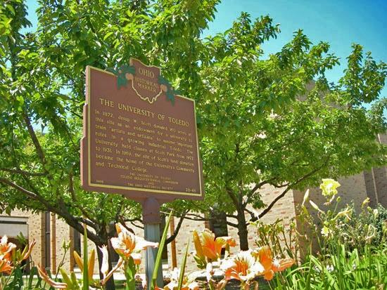
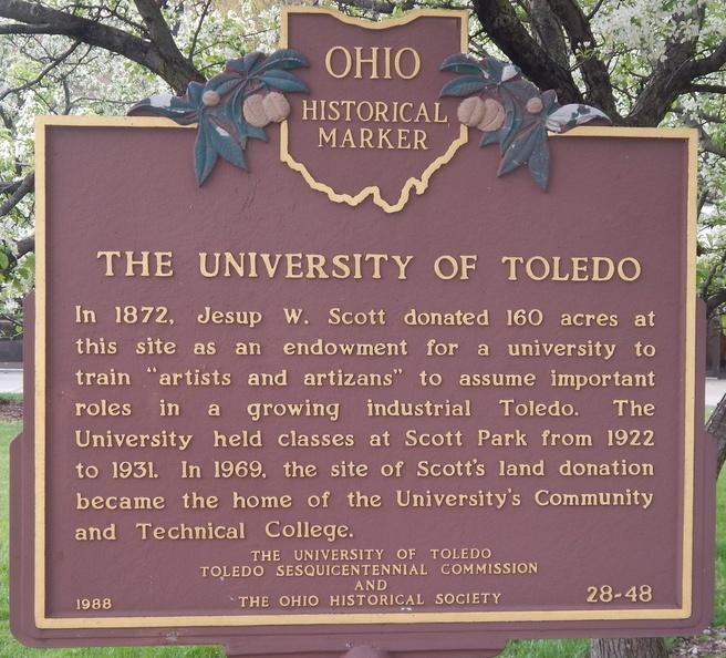
The University of Toledo, Scott Park (28-48)
")
Location: Take the first road to the right into the Scott Park Campus and follow it to the main campus entrance. There is no Google Stret View for this historical marker.
Text (Scott Park Campus, 28-48): In 1872, Jesup W. Scott donated 160 acres at this site as an endowment for a university to train "artists and artisans" to assume important roles in a growing industrial Toledo. The University held classes at Scott Park from 1922 to 1931. In 1969, the site of Scott’s land donation became the site of the University’s Community and Technical College.
")
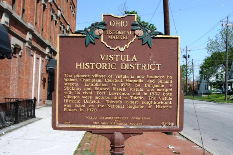
Vistula Historic District (6-48)
")
Location: southwest corner of Summit and Lagrange streets. [Google Street View]
Text: The pioneer village of Vistula is now bounded by Walnut, Champlain, Chestnut, Magnolia, and Summit streets. Established in 1833 by Benjamin F. Stickney and Edward Bissell, Vistula was merged with its rival, Port Lawrence, and in 1837 both villages were incorporated as Toledo. The Vistula Historic District, Toledo’s oldest neighborhood, was listed on the National Register of Historic Places in 1978.
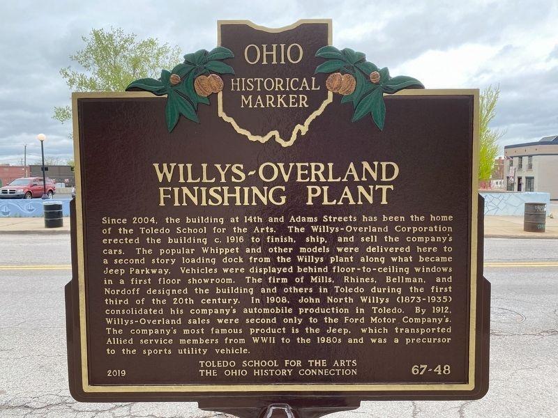
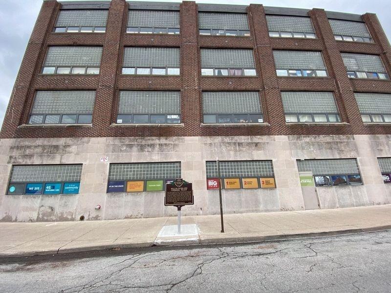
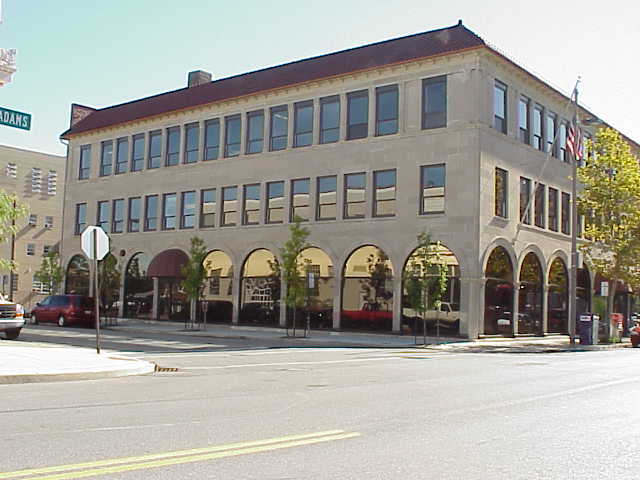
Willys-Overland Finishing Plant (67-48)
")
Location: Adams Street outside of the Toledo School for the Arts. [Google Street View]*
*Note:the 2019 image capture does not show the marker erected later in 2019
Text: Since 2004, the building at 14th and Adams Streets has been the home of the Toledo School for the Arts. The Willys-Overland Corporation erected the building c. 1916 to finish, ship, and sell the company's cars. The popular Whippet and other models were delivered here to a second story loading dock from the Willys plant along what became Jeep Parkway. Vehicles were displayed behind floor-to-ceiling windows in a first floor showroom. The firm of Mills, Rhines, Bellman, and Nordoff designed the building and others in Toledo during the first third of the 20th century. In 1908, John North Willys (1873-1935) consolidated his company's automobile production in Toledo. By 1912, Willys-Overland sales were second only to the Ford Motor Company's. The company's most famous product is the Jeep, which transported Allied service members from WWII to the 1980s and was a precursor to the sports utility vehicle.

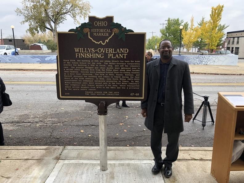
The marker on the Adams Street side of the School erected in 2019
")
Willys-Overland Finishing Plant marker (Adam street side)
Other Public Historical Monuments
This collection contains information and photographs related to sites of historical significance throughout Toledo, which are not historical markers.
Bicentennial Trees -- Catholic War Veterans Memorial -- Civic Center War Memorial -- Fire Fighter's Memorial -- Richard Gooser Memorial -- William McKinley Memorial -- Memorial Hall Monument -- Toledo Police Memorial Garden -- Port of Toledo Maritime Display -- River Walk: The Middle Grounds -- River Walk: Central Plaza -- River Walk: Warehouse District -- Spanish-American War Monument -- General Steedman Monument -- Veterans of Civil War Memorial Urn
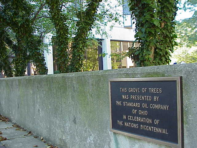
Bicentennial Trees

Location: Civic Center Plaza
Text: This grove of trees was presented by the Standard Oil Company of Ohio in Celebration of the nation's Bicentennial.
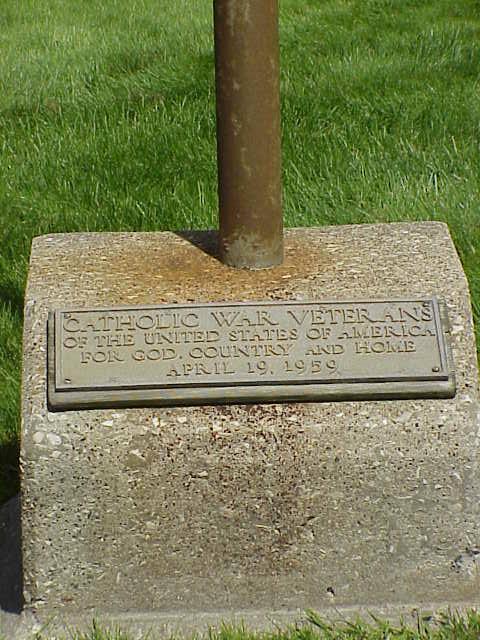
Catholic War Veterans Memorial

")
Location: Next to the Ten Commandments Monument on the Lucas County Courthouse Square
Text: "Cathoic War Veterans of the United States of America, For God, Country, and Home, April 19, 1959"
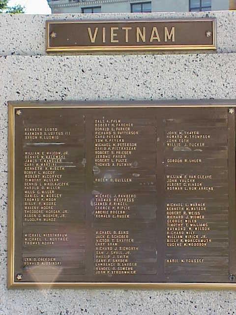
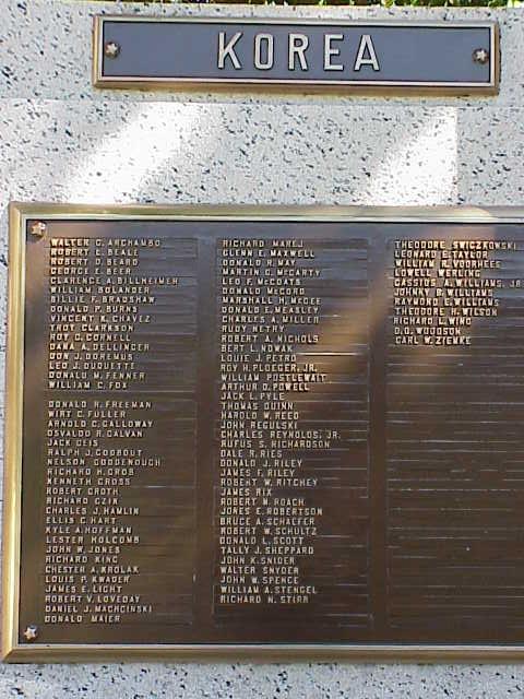
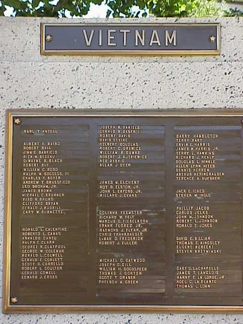
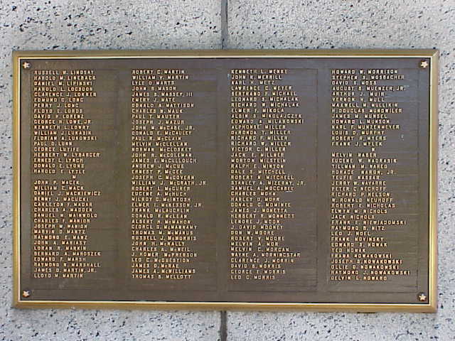
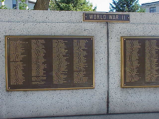
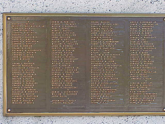
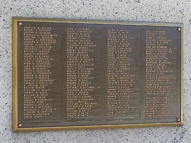
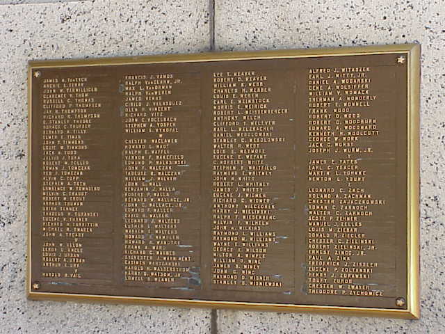
Civic Center War Memorial

Location: Civic Center, Downtown Toledo
Note: the fourteen plaques honor fallen soldiers fighting in World War II as well as the Korean and Vietnam Wars.
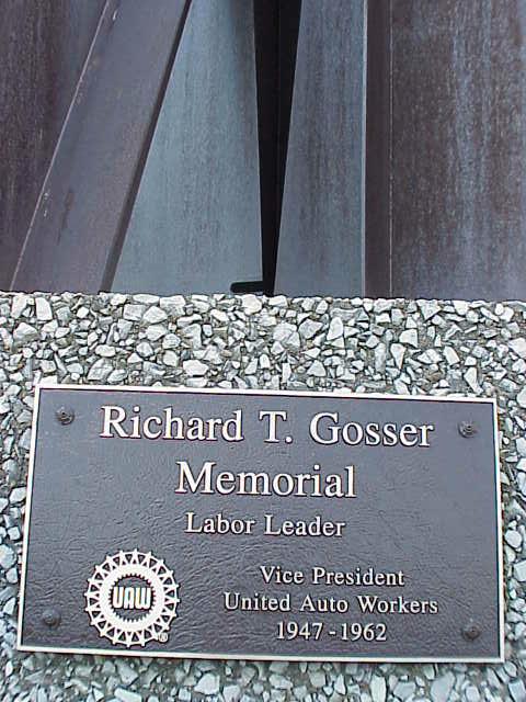
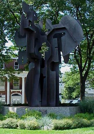
Richard Gosser Memorial


Location: At the intersection of Ashland and Woodruff Avenues [Google Street View]
Richard Gosser Memorial (left); Plaque (right)
Text:
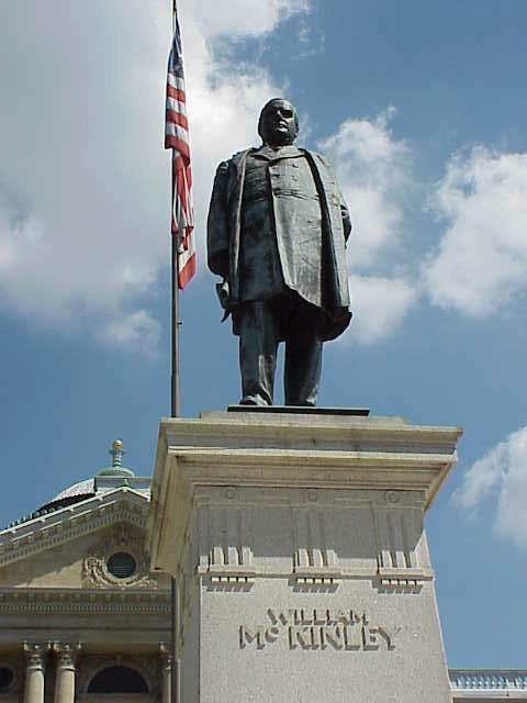
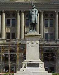
William McKinley Memorial
Location: The McKinley Memorial is located on Adams Street outside the courthouse. [Google Street View]
This is not a historical marker but is nonetheless important to regional history. Each side at the foot of this statue has a plaque with text presented below.
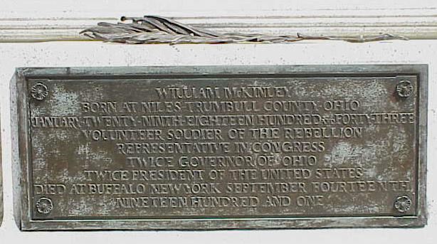
Plaque One

Text:
William McKinley - Born At Niles Trumbell County Ohio,
January Twenty-Ninth, Eighteen Hundred Forty-Three,
Volunteer Soldier Of The Rebellion,
Representative In Congress,
Twice Governor Of Ohio,
Twice President Of The United States,
Died At Buffalo, New York, September Fourteenth,
Nineteen Hundred And One
Plaque Two

Text:
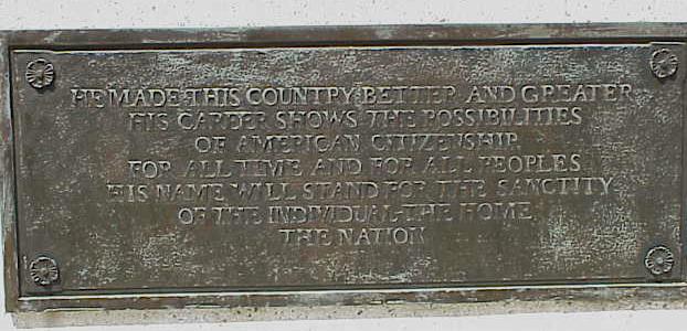
He Made This Country Better and Greater,
His Career Shows The Possibilities,
Of American Citizenship,
For All Time And For All Peoples,
His Name Will Stand For The Sanctity,
Of The Individual - The Home,
The Nation.
Plaque Three

Text:
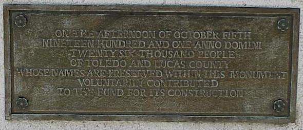
On The Afternoon Of October Fifth,
Nineteen Hundred And One, Anno Domini,
Twenty-Six Thousand People,
Of Toledo And Lucas County,
Whose Names Are Preserved Within This Monument,
Voluntarily Contributed,
To The Fund For Its Construction.
Plaque Four

Text:
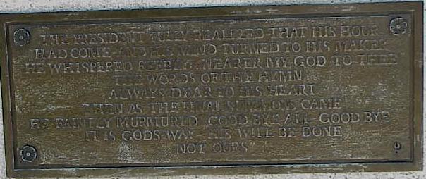
The President Fully Realized That His Hour ,
Had Come And His Mind Turned To His Maker,
He Whispered Feebly, Nearer My God To Thee,
The Words Of The Hymn,
Always Dear To His Heart,
Then As The Final Summons Came,
He Finally Murmured Good Bye All Good Bye,
It Is God's Way "His Will Be Done,
Not Ours"
Memorial Hall Monument

Location: Central Library, Toledo
Text: This marker commemorates the old Soldier's Memorial Hall that stood near this site until the 1950s. Memorial Hall was built by the donations of Civil War veterans and included both a Civil War museum and a public meeting hall that hosted many famous speakers.
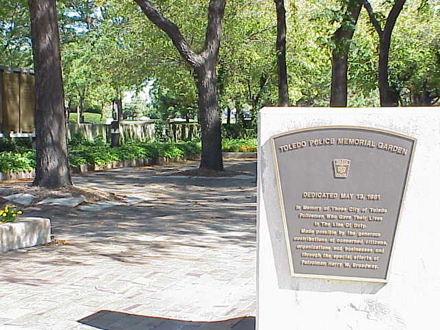
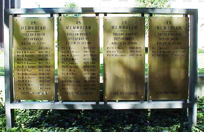
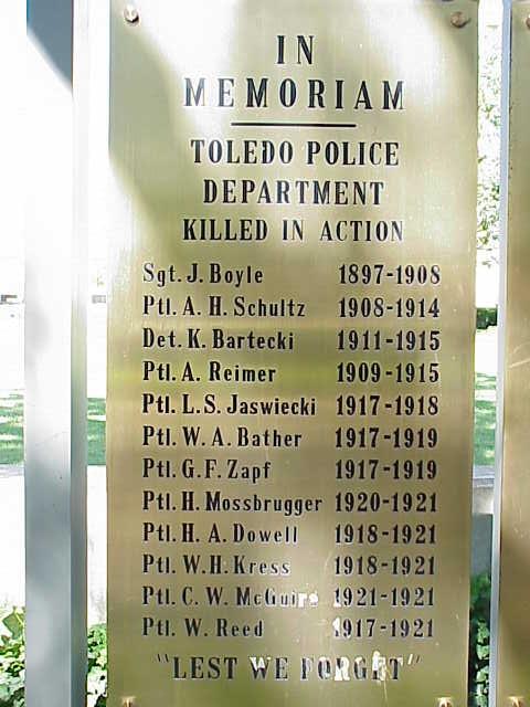
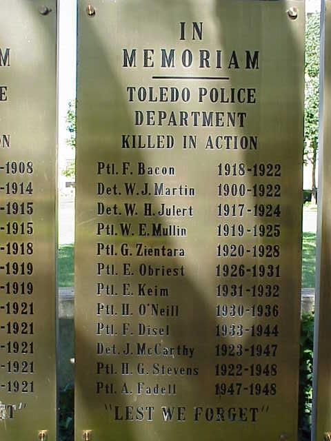
Toledo Police Memorial Garden

Location: Civic Center Plaza
Text:Toledo Police Memorial Garden - Dedicated May 13, 1981 - In Memory of those City of Toledo policemen who gave their lives in the line of duty.
Made possible by generous contributions of concerned citizens, organizations and businesses and through the special efforts of Patroman Harry W. Broadway. IN MEMORIAM - Toledo Polic Department - Killed in Action
Sgt. J. Boyle, 1897-1908
Ptl. A.H. Schultz, 1908-1914
Det. K. Bartecki, 1911-1915
Ptl. A. Reimer, 1909-1915
Ptl. L.S. Jaswiecki, 1917-1918
Ptl. W.A. Bather, 1917-1919
Ptl. G.F. Zapf, 1917-1919
Ptl. H. Mossbrugger, 1920-1921
Ptl. H.A. Dowell, 1918-1921
Ptl. W.H. Kress, 1918-1921
Ptl. C.W. McGuire, 1921-1921
Ptl. W. Reed, 1917-1921
Ptl. F. Bacon, 1918-1922
Det. W.J. Martin, 1900-1922
Det. W. H. Julert, 1917-1924
Ptl. W.E. Mullin, 1919-1925
Ptl. G. Zientara, 1920-1928
Ptl. E. Obriest, 1926-1931
Ptl. E. Keim, 1931-1932
Ptl. H. O'Neill, 1930-1936
Ptl. F. Disel, 1933-1944
Det. J. McCarthy, 1923-1947
Ptl. H.G. Stevens, 1922-1948
Ptl. A. Fadell, 1947-1948
Ptl. W.P. Boyle, 1958-1961
Ptl. D.C. Brown, 1955-1962
Ptl. W. Miscannon, 1967-1970
Ptl. J. Hassett, 1880-1880
Ptl. C.W. Russell, 1897-1906
Ptl. N.C. Smith, 1910-1911
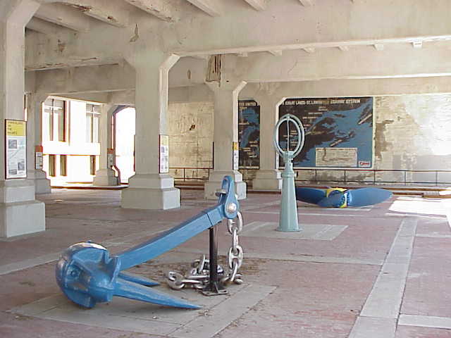
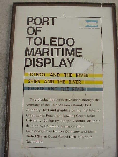
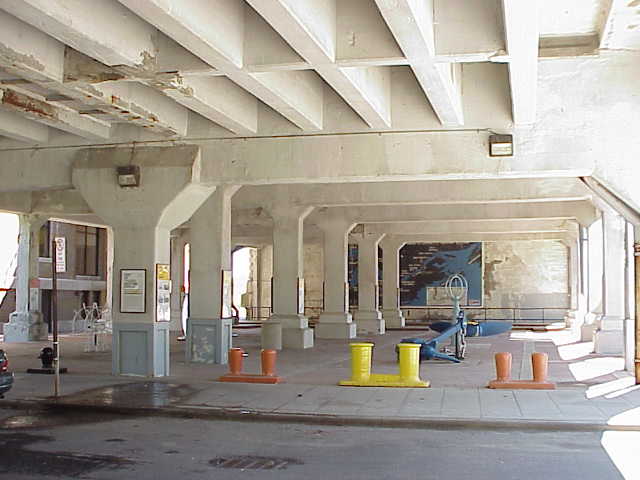
Port of Toledo Maritime Display


Port of Toledo Maritime Display, Anchor, and Sign
Location: Beneath the west approach of the Cherry Street Bridge

Text (on sign): Toledo and the River - Ships and the River - People and the River. This display has been developed through the courtesy of the Toledo-Lucas County Port Authority. Text and graphics by the Institute for Great Lakes Research, Bowling Green State University. Design by Joseph Vecchio. Artifacts donated by Columia Transportation Division/Oglebay Norton Company and Ninth United States Coast Guard District/Aids to Navigation.
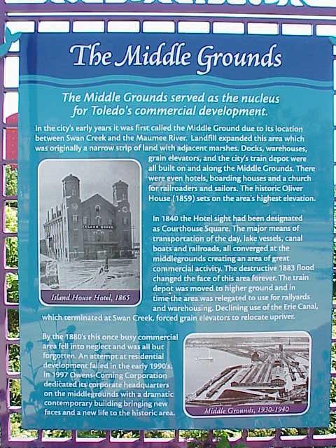
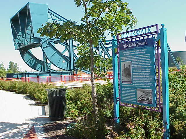
River Walk: The Middle Grounds

")
Location: Summit and Washington Sts.
Text: The Middle Grounds.
The Middle Grounds served as the nucleus for Toledo's commercial development. In the city's early years it was first called the Middle Ground due to its location between Swan Creek and the Maumee River. Landfill expanded this area which was originally a narrow strip of land adjacent marshes. Docks, warehouses, grain elevators, and the city's train depot were all built on and along the Middle Grounds. There were even hotels, boarding houses and a church for railroaders and sailors. The historic Oliver House (1859) sets on the area's highest elevation.
In 1840 the Hotel sight [sic] had been designated as Courthouse Square. The major means of transportation of the day, lake vessels, canal boats and railroads, all converged at the middlegrounds creating an area of great commercial activity. The destructive 1883 flood changed the face of this area forever. The train depot was moved to higher ground and in time the area was relegated to use for railyards and warehousing. Declining use of the Erie Canal, which terminated at Swan Creek, forced grain elevators to relocate upriver.
By the 1880's this once busy commercial area fell into neglect and was all but forgotten. An attempt at residential development failed in the early 1990s. In 1997 Owens-Corning Corporation dedicated its corporate headquarters on the middlegrounds with a dramatic contemporary building bringing new faces and a new life to the historic area
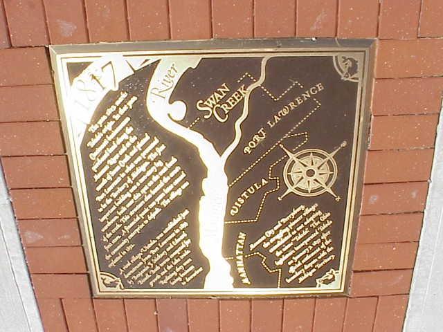
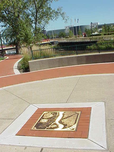
River Walk: Central Plaza

")
Location: Summit and Washington Sts.
Text: 1817
The year 1817 marks Toledo's origin. In that year Cincinnati businessmen purchased land along the Maumee River and at the mouth Swan Creek and platted Port Lawrence in what was presumed to be the Territory of Michigan. TRhe first important building was a two-story log warehouse, built near this spot on the west bank of the creek. . . A financial panic two years later caused the community enterprise to default. The village was replatted in 1832.
A rival village of Vistual was established just downstream from Port Lawrence in 1833 by Benjamin Stickney and Edward Bissell. Both towns competed for growth and the lake trade.
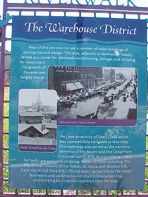
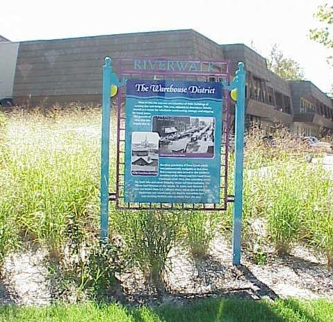
River Walk: Warehouse District
")
")
Location: Summit and Washington Sts.
Text: The Warehouse District
West of this site on can see a number of older buildings of varying size and design. This area, adjacent to downtown Toledo, served as a center for wholesale warehousing, storage, and shipping for many years.
The growth of this area was largely due to the close proximity of Swan Creek which was commerically navigable at that time. This waterway also served as the northern terminus of the Miami and Erie Canal from Cincinnati until 1913, thus providing access for both lake and canal shipping. Major rail lines including The Clover Leaf Division of the Toledo, St. Louis and Western R.R. (later the Nickel Plate R.R.) offered, direct rail service to the major businesses and warehouses. An electric interurban line and trucking facilities also operated from the area.
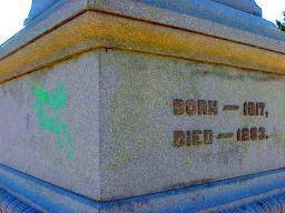
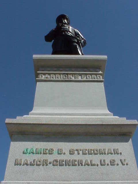
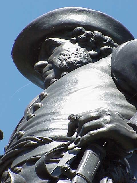
General Steedman Monument

Location: Summit and Ash Sts.
Text: Carrick's Ford - Chickamauga - James B. Steedman, Major-General, U.S.V. - Born 1817, Died 1883 - Erected by W.J. Finlay, 1888.
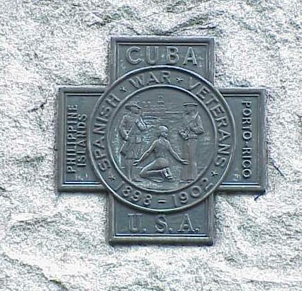
Spanish-American War Monument
Location: Lucas County Courthouse [Google Street View]
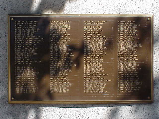
The Spanish-American Monument outside the Lucas County Courthouse (Jackson Street side) commemorates the 1898 conflict between the United States and Spain, resulting in the acquisition of former Spanish domains in Latin America and the Western Pacific. The roots of the conflict lie in the 1895 Cuban struggle for independence from Spain, which sought American intervention that prompted Spain to declase war on the US on April 21st of 1898. The US Navy and Army drove out the Spanish fleet from the Philippines and Cuba by May and July, respectively, bringing the conflict to en end by July 17, 1898. Under President William McKinley, Commo. George Dewey (US Navy), and Gen. William Shafter (US Army Volunteer Cavalry) have led the forces which also included Theodore Roosevelt who volunteered with the Army Volunteer Cavalry unit--the "Rough Riders."
 Spanish War Veterans Plaque, 1898-1902
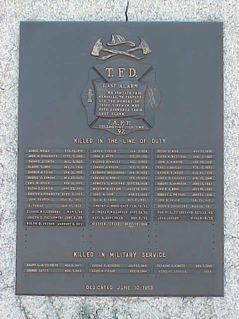
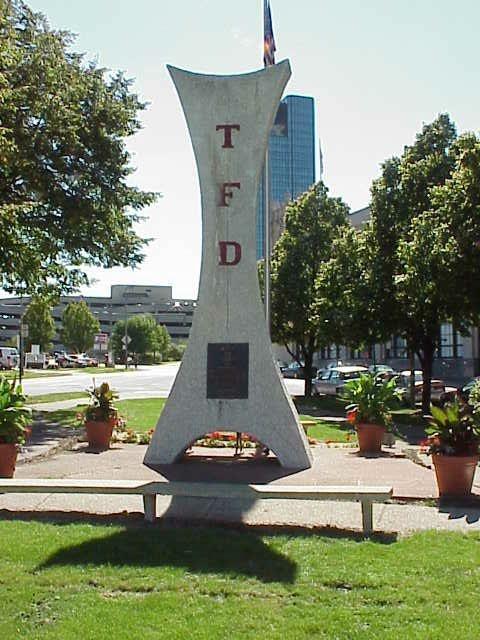
Toledo Fire Fighter's Memorial


Location: Huron and Beech Sts [Google Street View]
Toledo Fire Fighter's Memorial (left); T.F.D. Last Alarm plaque (right)
T.F.D.
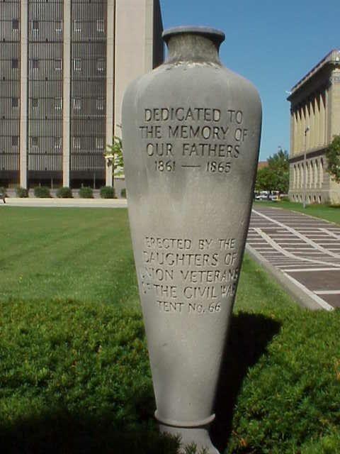
Veterans of Civil War Memorial Urn

Location: Civic Center Plaza
Text: Dedicated to the Memory of Our Fathers, 1861-1865. Erected by the Daughters of Union Veterans of the Civil War, Tent No. 66.
There are many more historic places throughout Toledo and surrounding communities that have not been recognized for a historical marker or monument but nonethtless are significant in the historical context of the city and its community.
Bank Row -- Dorr Street -- Swayne Field -- Toledo's Labor Temple
Bank Row


Location: Foot of Madison Avenue, Toledo
This two-block strip of Madison Avenue was Toledo's financial district. On this corner in the summer of 1931, thousands of panicked depositors crowded to remove their savings from the city's banks. All but one bank closed their doors and liquidated in the Great Depression.
Dorr Street

Location: Dorr runs from Washington St. West to the city limits.
Dorr Street was the commercial heart of the African American community until it was destroyed in a fit of "Urban Renewal" in the late 1960s. Residents were displaced amid promises to "rebuild" the community. Even today, thirty years later, much of the area remains empty grassy lots.
Swayne Field

Location: Monroe and Detroit Avenues, Toledo
Swayne Field was the home field of the Toledo Mun Hens. Over this wall flew balls hit by many baseball legends.
Toledo's Labor Temple

Location: Corner of 10th and Adams Sts., Toledo
Built with the individual donations of thousands of Toledo's trade unionists, the old Labor Temple was the site of many events in the city's industrial and social history.